A Month of Alpine Fun


29th Dec 2017 – 1st Jan 2018 – Khancoban and surrounds

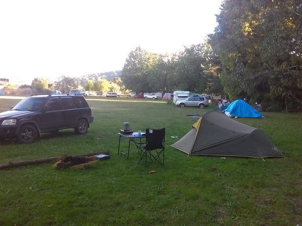
The last weekend of 2017 saw me and my Beloved camping at Khancoban, in New South Wales. Part of the reason we went camping was to try out our new 4 man tent. But Rebecca (my Beloved) suggested that I find some things for us to do over the weekend, so being a good husband I did as I was told. Khancoban is the south-western gateway to the Kosciusko National Park, which has plenty of exciting and beautiful places to visit, a lot of them requiring hiking or mountain biking to see. There are also a number of National Parks and State Parks not far away in Victoria. So thats what I happened to find – lots of walking as I didn’t think I would be taking my mountain bike. My Darling is not much of a walker, but she was willing to accommodate my planned activities, at least as far as she was able. When we arrived at Khancoban, the weather was looking a bit threatening, with low clouds. And in the evening and overnight we had a lot of rain. We discovered that our tent leaked, although it required a significant downpour for that to occur, and it’s possible that we didn’t put it up properly in the first place.

On Sabbath, with the bad weather having cleared away and the weather looking promisingly sunny, we drove to the Burrowa-Pine Mountain National Park on the Victorian side of the Murray River near Cudgewa. We had only been there once before, and due to flood damage many of the tracks were closed at that time. This time the tracks were open. So we started by hiking to Bluff Falls and having look at them. Then it was up, up, up to Campbells Lookout. This track really wasn’t exactly what I was expecting. Although to be honest I didn’t really know what to expect. The track had lots of stairs, lots of scrambling over rocks, it even had a 5 metre or so vertical ladder to get up one particular section. Quite an adventure. But the scenery was magnificent, with great views, dramatic rock faces and formations, and fern gullys punctuated by the creek which runs down the middle of the valley.

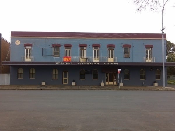
Following the Campbells Lookout walk, we had some lunch then engaged in the much more leisurely pursuit – going for a drive through the countryside. And then we returned to Khancoban Caravan Park. While my Darling had a rest (ie, sleep), I went for a bit of a walk over the Khancoban Lake wall and into Khancoban itself, just to see what was around. There were boats and water-skiers in abundance on the lake. The Rose Garden in town looked like it had seen better days, but maybe that’s because it was being prepared for the next Rose season. In any case, the walk was interesting. And by the time I got back to the caravan park it was approaching dinner time.

On Sunday, New Years Eve 2017, the plan was to drive up the trail head near Tooma Dam, and then walk out to Paton’s Hut. But as is often the case, plans don’t always eventuate. We got to the trail head ok, and hiked most of the way, probably to within about 400 metres of the Hut, then Rebecca got bitten by something (no, not a snake!), and rather than complete the walk it seemed best to return to the car. It was a case of so close, yet so far. Rebecca suggested I go on another walk while she sat in the car and read a book, but I didn’t particularly like that idea, just case she had some sort of alergic reaction to the bite. So we drove back towards civilisation. At Corryong we had some lunch, and then we went and had a look at the Man From Snowy River Museum in the town.

Then it was back to Khancoban, where we found a nice shady spot and watched the boats, jet skis and water skiers enjoying themselves on the lake while we indulged in an ice cream and sat in the shade, at least for a while. Then we went back to the caravan park. At the caravan park, they had a Pizza night as a way of celebrating New Years Eve. And it seems that New Years Eve celebrations went on for a lot longer as every time we woke up during the night it seemed that there was loud music playing somewhere. Until the wee hours of the morning.

6th – 7th January – Bogong High Plains / Dinner Plain.

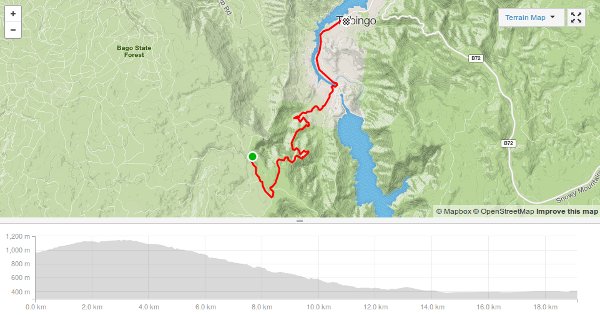
On the weekend of the 6th and 7th January, 2018, it was going to be hot. At least down on the plains where we live in Culcairn. On Sabbath I decided I wanted to go for a walk, and my Darling wife suggested I camp somewhere overnight to try out my new hiking tent. I didn’t take much convincing! Within about an hour I had enough food for an overnight camp, all my camping stuff and clothes suitable for hiking. And so I headed for the mountains. The plan was to drive to Dinner Plain, just downhill a ways from Mt Hotham, and do some hiking there then find a place to camp overnight. After looking at maps I decided I would walk the Carmichael Falls walk and then depending on how I felt and how hot it was I would consider another walk. The Carmichael Falls walk from Dinner Plain isn’t that long, but it turned out to be quite steep. It was like walking through a well tended rock garden with beautiful flowers, ferns and other types of plants everywhere. And then there was the falls themselves. They weren’t overly spectacular as it was the middle of Summer. But the rocks from which they fall was definitely worth the walk. Then on the way back I took a short detour to another cascade that looked distinctly man-made with the creek cascading over very symetrical rock steps. Although I’m pretty sure it was completely natural.

After completing the Carmichael Falls walk, I decided I would walk to Precipice Plains lookout. By comparing the distance on the map for the Carmichael Falls walk I figured it would be about 10km return from the Carmichael Falls track. And as it turns out I was pretty close. By this time of the day it was getting warm-ish, but still nowhere near as hot as it would have been at home. Precipice Plains is a geological feature where the Dargo River valley is surrounded by high cliffs. I guess thats where the “Precipice Plains” name comes from. The walk itself was along a 4WD track with alpine forest on both sides. It was quite a pleasant walk, with a breeze blowing across the track most of the time and shady sections where the trees overhung the track. As the wind was quite strong at the lookout I stayed well clear of the edge of the precipice. But even so, the views across to the cliffs north and west of the lookout were quite spectacular.

After I returned to the car, I decided I would check out the JB Plain camping area. It was rather pleasant, and it would have been even more pleasant and quiet as there was no-one else there. But I decided I would drive to Anglers Rest, on the Cobungra River, and camp there instead. This meant driving down to Omeo from Dinner Plain and then driving along the Omeo “Highway” north to Anglers Rest. I knew there were a number of camping spots there. I didn’t realise how busy the camping area just down the road from the Blue Duck Inn would be, but I managed to find a spot for my small hiking tent.

The name “Anglers Rest” is very descriptive of the area, and is a popular fishing spot as it is near the junctions of 4 rivers – Mitta Mitta, Cobungra, Bundarra and Big Rivers. People travel from some very long distances just to fish in the area. The area is also popular for horse riding, mountain biking, white water rafting, camping and hiking.  It is nestled near the bottom of the valley, and is very picturesque. But the Omeo “Highway” is not for the faint hearted. It was even more of an adventure in the Gold Rush days as it was only a walking track then between Omeo and the Mt Wills goldfields. Even though it’s all asphalted now, it’s still quite an adventure as it is narrow and winds it’s way around the mountains to connect Omeo in the south and Mitta Mitta in the north.

After a fairly restful night, I rose early and had breakfast, packed up camp and drove to the Bogong High Plains near Falls Creek. My first walk for the day was the Mt Cope walk. It wasn’t very long, being 3km return, but the walk was along a very picturesque trail and the 360 degree views from the summit were well worth the effort. Along the way I chatted with an Army person who had his full combat uniform complete with helmet and what appeared to be a very heavy army-issue backpack. He wasnt hiking very fast, but then you wouldn’t expect him to with all the weight he must have been carrying. He was able to identify most of the mountains around, including Kosciusko many kilometres away. He also told me of some good hikes around Falls Creek and Bogong High Plains, which wet my appetite for some more adventures in the area.

After the Mt Cope hike, I drove a little way towards Falls Creek, and parked the car for a hike to 2 alpine huts. Huts in alpine areas of Australia generally fall into about 3 categories – 1) huts built by cattlemen many years ago to aid in the movement of cattle between the high plains and the valleys (and possibly rebuilt after a bush fire or something else requires it), 2) huts built by government agencies such as the National Park service for the use of visitors (for example, snow skiers), and 3) huts built by other organisations such as schools or clubs. I’ve been very interested in alpine huts ever since I acquired and read a book about the mountain cattlemen and huts of the high plains. Interest in alpine huts also increased in my early adult years due to another book I read about the history of snow skiing in Australia which talked about various huts in it’s narrative, and my own personal interest in and enjoyment of snow skiing (before I met Rebecca I went snow skiing whenever I could, often every Sunday). Movies such as the “Man from Snowy River”, which featured the beauty of Australia’s alpine areas also played a part in my interest. The two huts I visited on the Bogong High Plains that day, Wallaces and Cope Huts, seem to be huts initially built by cattlemen.

Up in the Boging High Plains that Sunday was very pleasant – around 25 degrees Celsius. When I stopped briefly in Mt Beauty on the way home, it was certainly a lot hotter than when I was hiking in the high plains.

A plan not realised

Over the Australia Day weekend in late January I had a plan to head for the hills again, and had sort of set my mind to camping and exploring the Snowy Mountains / Kosciusko National Park near Jindabyne, New South Wales. I had all the camping gear packed, all the food purchased and was all mentally prepared. And then rain, thunderstorms, and the like were forecast for exactly where I planned to go. So I checked other places such as around Falls Creek and Mt Hotham – the same sort of weather was forecast. I checked the forecast for some places outside the mountains, and the forecast there was for 35+ degrees Celsius. I realised that I could either risk getting caught in  electrical storms and being stuck in a hiking tent during the forecast rains, or risk getting severly sunburnt, or stay home. Guess which one I chose?

Along the Roads to Gundagai


There’s an old Australian folk song called “Along the Road to Gundagai”, and it lyrics are…

There’s a track winding back
To an old-fashioned shack
Along the road to Gundagai.

Where the blue gums are growing
And the Murrumbidgee’s flowing
Beneath the sunny sky,

Where my daddy and mother are waiting for me
And the pals of my childhood once more I will see.
Then no more will I roam when I’m heading right for home
Along the road to Gundagai.

Apart from the lines “Where my daddy and mother are waiting for me, and the pals of my childhood once more I will see” the rest of lyrics indicated above were my experience over the last week, especially when “home is where the heart is” (ie, anywhere my darling wife happens to be). But Gundagai was the end, the destination, of a cycling adventure.

September 11th, 2017.

The cycling adventure started on the date that has unfortunately etched itself in the Western pysche – September 11th. But the events of many years ago were furthest from my mind as I left Henty bound for Wagga Wagga via Mangoplah in NSW. This was day one which involved a long 70+ km bike ride, with my Topeak rack and bag on the back of the bike and a back pack on my back. Those bag and pack had in them everything I thought I would need for 5 days of cycling, minus sleeping gear as that was provided at the various places I stayed. The weather was good, but I did have a headwind for pretty much the whole ride so it was hard going and by the time I got to Wagga Wagga I was really looking forward to some lunch and a well earned rest. The cycling for day one was over roads I had travelled before on a number of occasions so it was all pretty familiar. I knew where all the hillss and all the major landmarks were. So that was more a re-acquainting that a true adventure, although it was the first time I was kitted out for a multi day ride along those roads. Wagga Wagga is a large town nestled along the banks of the Murrumbidgee River, which is also the river that the township of Gundagai is on.

September 12th.

One thing I did while in Wagga Wagga was I walked some of the Wirajuri Trail which I had never walked before – eventually I hope to walk and / or ride the whole 40lm trail around Wagga Wagga. After a fairly good night’s rest I left Wagga Wagga early in the morning, heading towards Junee about 40km away. This proved to be a very interesting day for me as I am very much interested in railways and trains, and most of the journey is close to the Main South railway line that connects Melbourne (in Victoria) and Sydney (in NSW). I saw a number of railway features and some trains during the day.

It was also the first time I had travelled that route between Wagga Wagga and Junee. But that head wind persisted and after about 30km I was really feeling the fatigue. That might seem strange when I can normally ride around 80km before the fatigue sets in but when I ride 80km or more I try and avoid headwinds on the last half of the ride and I have nowhere as much weight attached to me or the bike. I got to Junee a bit before lunch, and so went to the cafe attached to the railway station and purchased some lunch – a vegetarian club sandwich and something for dessert. As I had about 2 hours before I could book into the Junee Tourist Park I found a seat and had a good rest, watching the world go by. After I checked in to my accommodation for the night I went for a bit of an explore on the bike on the various trails and roads around Junee. Junee is a railway town. If iot wasn’t for the railway the town would probably not be the size it is. There is a 360 degree roundhouse, and it is the junction of the Main South line and a line that branches off to Narrandera and Griffith. In more recent years, the de-regulation of the Australian railway industry and the move to containerised freight has led to the establishment of a transhipment facility at Harefield and so the railway yards at Junee often have railway carriages bound for or moved from Harefield. I heard a number of freight trains rumbling through at various times of the day and night along the Main South line and the Griffith branch. So even today the railwys are busy in and around Junee – that warms the heart of any railways fan.

September 13th.

This day was to prove very different to the previous two.  It was a bit cooler, more overcast. But the best thing about this day’s major bike ride was that it had lots of downhill and a tailwind! My destination was Bethungra. I rode along Old Sydney Road for this ride, which in the days of the Cobb and Co coach service was the route they took between Junee and Bethungra. The road was great to ride on, the hills not beeing too steep, and through beautiful farming country. The reason I decided to take this road was that I don’t like riding on major highways, so to avoid the Olympic Highway, the most direct route between the towns I had to go along Old Sydney Road. This road was entirely unknown to me before I that day but I am glad I decided to ride it. Bethungra is another township very much connected with the railways. Nearby is the Bethungra Spiral, a railway feature built in the 1940’s to minimise the need for double-heading or banking of trains to get them over the mountain range. “Double-heading” means adding an extra locomotive to the front of a train, and “banking” means more or less the same thing – but the extra locomotive is often added to the back of a train to push the train while the locomotive at the front pulls the train. As the name implies, the Bethungra Spiral winds around and goes over itself, using the spiral to gain or lose height meaning gradient is less steep. Bethungra once has as many as 3000 people, but when the railways mechanised and restructured their track work gangs the town almost died, although today it seems to be a small but vibrant village of community minded people.

After checking into the Bethungra Hotel B&B at Bethungra I rode out to the Spiral to take a look, and to the Bethungra Dam / Lake which has a good camping area, and explored the railway features in Bethungra township itself. I also visited the Olde Schoolhouse T-House and had a good chat to one of the operators. It was interesting to find out that they are of the same worldwide faith community as me, and so I chatted for quite some time before going back to the B&B and engaging in some major relaxation – ie, sitting on the balcony outside my room and watching the world go by and hoping for some trains to pass by in easy view of the B&B. But alas the only trains that travelled by were an XPT passenger train (which I saw on the Spiral itself when riding out there) and trains going through at night! Oh well.

September 14th.

Old Sydney Road which I rode the previous day showed on the map as a fairly straight rode. The route for this day’s ride was a very winding one from Bethungra to Cootamundra very much away from the Olympic Highway. When I compared the maps for the two days, I figured that this day’s ride would be much more hilly than the previous days due to the constant changes in direction of the roads on the map. And I was right.From about 15km into the ride until about 10km from Cootamundra it was a fairly constant pattern of ascent followed by descent. Ans so 40 or so kilometres and about 2 and a bit hours later I arrived in Cootamundra. This day was a very cold day, around 8 degrees Celsius. While I was riding that didn’t pose too much of a problem as the effort required to ride up the hills and the 3 layers of clothing I had on tended to keep me warm. But once I stopped at Cootamundra and started to cool down, the wind also seemed to pick up. and so I had to add an extra layer of clothing. Thats’ right – 4 (four) layers of clothing and I still wasn’t feeling particularly warm! I was very thankful for the warmth of the cafe where I had lunch and the wonderfully working heater in the hotel room I had booked for the night. Like Junee, Cootamundra is a very busy railway town. On my exploring around town I saw some locomotives I had never seen before. There is also a foot bridge over the railway lines that gives a good view of the yards and station.

IMAG3788

White Ibis Hotel, Cootamundra. Where I stayed for the night.

September 15th.

This was the last day of my cycling adventure. The previous night I had developed a sneeze or hay fever.  I was hoping that wasn’t a sign that I was getting sick as this days ride was 50+km and I was expecting some major climbs along the ride. As it turned out I needn’t have worried about either as the climbs weren’t that bad and once I was warmed up on the ride the blocked / runny nose stopped being blocked / runny. This ride was in a south easterly direction to Gundagai through the locales of Brawlin and Muttama and for part of the way it followed the now disused Cootamundra – Gundagai – Tumut railway branch line. Spring is a beautiful time to out riding in the south-eastern Australian couttryside as the canola is in bloom and the blossoms of various flowing trees (native and introduced) are also blooming. But then there is the magpies, who also swoop in early Spring. Interestingly, most of the viscious swooping magpies were in the towns (what I call “Town Magpies”). The magpies in the countryside (“Country Magpies”) still swoop but often not as visciously as Town Magpies – another reason to be riding in the countrside in spring rather than in the towns!

I arrived at Gundagai not long after my wife and one of my daughters arrived there and once I Put the bike on the car the cycling adventure was finished. But I had made it. With 284km of riding, mostly through countryside that I had never been or seen before, it was very interesting and enjoyable. And I discovered, or maybe remembered, some things:

  • It is not impossible to find people with whom you have a common interest in the most unlikely of places.
  • Country hospitality really is the BEST!
  • Exploring new places is inherently pleasurable and interesting on a bicycle.
  • While the destination is important, the journey is to be savoured and enjoyed.

Ernest Hemingway once said of cycling “it’s by riding a bicycle that you learn the contours of a country best, since you have to sweat up the hills and can coast down them”. Bill Emerson said “a bicycle does get you there and more. … And there is always the thin edge of danger to keep you alert and comfortably apprehensive. … And getting there is all the fun”. But for this cycling adventure (and many others), Charlie Cunningham sums up my feelings best: “You’re moving through a wonderful natural environment and working on balance, timing, depth perception, judgement… it forms a kind of ballet”.

Batlow Biking


Batlow, not far from of the Snowy Mountains, and somewhat succeptible to snow itself, was the decided destination for a cycling holiday with a difference. Normally I look for rail trails to ride, and often in the state of Victoria – a veritable mecca for rail trails! But on Wednesday 5th April, right after I finished work, the car being packed the night before, I left home and drove 2 and a bit hours to Batlow Caravan Park, my base camp for some days of cycling adventure. The plan was to stay a week and ride as many roads and see as much as possible. As I had never ridden any of the roads or tracks in the region except south of Tumbarumba. So it was really virgin cycling territory for me. I was somewhat aware of the terrain, though, because I had driven through the area on a number of occasions.

Batlow_CaravanPark_2664

My ‘home’ for a few days while exploring the Batlow area

The first bike ride which took 11 hours from start to fnish was quite an adventure. I left the Caravan Park on Thursday morning at arounf 7am, and didn’t get back until around 6pm. It was one of those bike rides that was not necessarily fun at times, but even now a few days later I look back on it with pleasant memories. Here is how the ride went.

I rode from Batlow along Bago Forest Way, and stopped first of all at the Pilot Hill Arboretum. I had been there before, but never ridden there. The ride was uneventful, and quite enjoyable along logging roads and mostly through pine forests with the occasional breathtaking view across to the Snowy Mountains.

From Pilot Hill, the plan was to ride along roads and tracks I had never been along before (driving or riding) through to Talbingo via Snubba Road, and Browns and De Beauzevilles Tracks. Buddong Falls is about 30kms from Batlow, and has a small (very small) camp ground and it quite isolated no matter how you plan to get there. Browns and De Beauzevilles Tracks would be quite slippery and muddy after rain as would the approach from Talbingo. Thankfully there had not been any rain for a while and they were nice and hard to ride on. One thing that I did notice was the large amount of piles of manure – evidence of wild horses. Brumbies marking their territory I was informed. Buddong Falls themselves were quite beautiful, but I suspect there was more falls even more spectacular further along the walking track but as the walk was quite precipitous in places (increasingly more so the further I walked along it) and as I was by myself I decided it would be best to not go too far from where I had left the bike at the Buddong Falls camping area.

From Buddong Falls I headed towards Talbingo, a small ex-Snowy Mountain Scheme town nestled at the foot of the Snowy Mountains, a ride of about 20kms. From the Falls there was a 2 or 3km climb to the Powerline Track which as can be imagined followed the high voltage power lines over the mountains. The Powerline Track itself was mostly downhill, of varying steepness. The disk brakes on the bike really had a workout on this section and I had to stay very focussed on the road surface and my speed to ensure the bike was under control. As I am not a reckless downhill rider this presented no real problem! Although it did take me quite a while to descend to Talbingo. The views on this section were amazing with views right down into Talbingo, and across the mountains, especially where the track was on exposed ridges.

BuddongFalls-Talbingo-Ride-Map

Not long before Talbingo is the Tumut 3 Hydro-Electric Power Station. probably not very big by world standards, but quite impressive with the very large pipes snaking over the mountains from above it to feed water into it.

At Talbingo I stopped for some lunch, although I knew I couldn’t stop for too long – by then it was about midday, and I still had (I thought) about 30 kms to get back to Batlow and I knew there was going to be some major climbing to get back with the possibility of that section avergaing about 10kph. At Talbingo the battery on my Polar sports watch went flat as using the GPS and heart rate monitor on it will do that after about 5 hours of riding. So I switched over to the phone for the rest of the ride, and when I did so I found that the phone only had 30% charge on it. Oh well, I still wanted to track the ride as far as I could so I turned on the Strava app. Then after riding along the Snowy Mountains Highway for a few kilometres I go to the turnoff to Batlow along Yellowin Access Road. At this point the climbing started. And it wasn’t just a few percent climbing grade, this was sometimes as much as 16-20% incline (thats 1:5) according to Strava! I certainly felt those climbs.

About 17km from Talbingo there was a nice big yellow sign saying “Detour to Batlow”. So I turned right onto the road indicated. I thought, and hoped, it was the Snubba Road. But as it turned out it was an un-named track that went down to the Lake Blowering foreshore to detour around some areas closed for logging purposes. It was along this road that a kind of panic set in for a while when I realised what the time was, and how muich further I had remaining to get bacl to Batlow. What added to that was the realisation that the looming mountain range on my left had to be climbed before I could get back to Batlow, and I was starting to experience some pretty painful leg cramped and a general lack of energy. I was also not entirely trusting of there being any further detour signs or that I would reach a “dead end” on the road, as when I drove this route in the opposite directions some time ago when trying to get to Talbingo from Batlow we were confronted by a closed road sign which meant we couldn’t get to where we wanted to, and I was a bit concerned the same thing might happen this time.

It was about that time in the day that I checked my phone, which had been happily tracking my ride by GPS, but was now down to 4% battery charge. I decided to stop tracking the ride on the phone to conserve the battery, as I realised that it may have been after dark that I got to Snubba Road and that I might have to “camp” in the bush over night if I ran out of light. And I wanted to inform Rebecca (my wife) of this possibility once I got onto Snubba Road where I was fairly sure there would be mobile phone signal. There certainly wasn’t much signal for at least an hour before I would reach that road.

Along this section by the Lake Blowering foreshore I encountered some kangaraoos on the road, and while I was concentrating on those in front of me I saw out of the corner of my eye another one crouched on the bank, and as soon as I saw it, it jumped OVER the back of my bike! That was scary! A few kilometres further on I heard a single screach / growl / snort kind of sound. Where on earth had I come? And what on earth produced such a sound?I decided the best thing to do was to keep going. Thankfully no other scary sounds or anything like it happened, and it wasn’t long before the climb up to Snubba Road started in earnest. By this time I was walking the bike rather than riding it as the climb was just to steep for my cramping and unenergetic legs. And about every 30 minutes I was taking a 5 minute rest and eating some trail mix to try and build my energy. After about an hour or so of climbing I finally reached Snubba Road. And after one last hill to walk the bike up on Snubba Road, and then I finally was able to hop on the bike and pedal along as the road levelled out. Man, was I thanklful to be on Snubba Road. Not long after I arrived at the turnoff along Yellowin Access Road, which led me down into Batlow. By the time I saw the apple orchards on the outskirts of Batlow and the townhip itself nestled against the opposite hill it was just before sunset. I don’t think I have ever been so happy to see a town before as what I did that evening. By the time I got back to Batlow I had travelled an estimated 100+ kilometres, 80km (and 1800 metres of climbing) of which was tracked by GPS on Strava. The rides on Strava are:

The next day I decided I would drive to Tumut and ride some of the trails there. I found out that Tumut has Mountain Bike (MTB) trails in the state forest on the edge of town and I wanted to experience them. I started with the Mundowie Loop, and then part way along turned onto the Womboyne Loop. This brought me back onto the Mundowie Loop again which completed by riding back to the car park. Then I noticed a loop that wasn’t on the map – the Creek Loop. So I rode that as well. While the previous day’s very long ride was very suited to a mountain bike (mostly dirt roads and vehilcle tracks), most of the trails at Tumut State Forest park are single track – that is, about the width of a walking track. I haven’t done much MTB single track rides, but thoroughly enjoyed the hour or so I enjoyed riding those trails. Then after I had done all the intermediate level trails there, I proceeded down into town and rode the town trails along the riverside, and the wetlands areas next to the Tumut River. After the very long and arduous ride I did the day before, the 20 or so kilometres ridden while exploring Tumut’s state forest and riverside was a welcome change.

The next day was Sabbath. Normally I don’t ride my bike on Sabbath (although occasionaly I do). I decided to explore some of the walking tracks in the state forest around Batlow on foot and contemplate the universe (yes, men can do more than one thing at once). I am still not sure whether I walked all the ones on the signage I saw, as I only saw the two signs – one at the start and one a short way along – so I don’t know whether I got to the destinations mentioned on the first sign. But I did see some good views of orchards (of which there are many around Batlow), and views over to the distant hills. I also explored the Reedy Creek park a short distance from the Caravan Park. It was the site of the first Olymp[ic-sized swimming pool to be built in the entire district. The swiming pool was suggested by Mr Sam Ross, the president of the Batlow Progress Association. This is recognised as the beginning of the “Learn to Swim” campaign. The original pool had wooden board sides, and the concrete construction was completed in 1934. Because the pool was the only Olympic-sized pool in the district many other towns travelled to Batlow by car, bus and train to hold their swimming carnivals at the pool, even from as far away as Wagga Wagga (115km away), Cootamundra (120km away) and Junee (105km away). Today all that remains of the pool is what looks like a section of concrete that might have been part of the sides of the pool and a green expanse of grass.

Saturday night or maybe before dawn Sunday morning the rain started. And the thunder and lightning. I thought maybe it would stop by sunrise. But that only revealed looming dark grey clouds moving quite quickly over the town, and with each new batch of clouds another heavy shower. No riding today! So I spent most of the day driving around the district exploring roads that I might have otherwise ridden the bike along. I tried, in vain, to find the site of the Kunama railway terminus. I think I was in the correct general location (I travelled along Back Kunama Road to try and find it), but if the remains are on provate property, which the nswRail.net states is the case, then that explains why I didn’t actually find it. The nswrail.net site did have some photos of the Kunama station, including this one of the station platform and building.

I also found saw interesting local points of interest, including the “White Gate” at the corner of Tumbarumba – Batlow Road and old Tumbaraumba Road and a poem about a “Fallen Tree Hotel” at the same location.

"On the lonesome line of traffic
Where the Tumbarumba track
Forks for Bago and for Taradale as well
Where the wallabies and wombats
And the kangaroos have combats
I once beheld the Fallen Tree Hotel"
(Will Carter)

I explored the now very disused and somewhat derelict railway infrastructure at Batlow. It’s a pity such railways aren’t still in use and I always find it a bit sad seeing railways that were once an important part of a community being neglected and disused. There is talk of the Batlow railway being converted to a rail trail for use by walkers and cyclists. That would be much much better than letting it rot and rust away, and at least the general community and visitors could enjoy the scenery of what must have been a very scenic railway to travel on in it’s day. But alas some landholders think that turning the old railway into a rail trail on still government-owned land is somehow disrepecting the landholders that border the proposed trail. It’s a pity those landholders don’t have the same progressive spirit that drove Sam Ross to suggest doing something new in the district which led to the building of that Olympic sized swimming pool in Batlow all those years ago! He encouraged the building of the pool, and people came from miles around to use it, and I dare say some of the visitors money got spent in the town, and there was a general community benefit from having such an asset. A rail trail to Batlow is likely to generate the same sort of economic and community benefit. Narrow self-interest too often gets in the way of real community progress.

As the rain was not slowing down, and the forecast was for more the next day, and as my sleeping bags were wet, and the forecast was for near-freezing temperatures overnight I decided to cut my Batlow adventure short and head for home. So after a very fast packing up of gear, I settled in for the drove home and arrived home at about 9pm to cuddle up to my wonderfully warm wife for a good nights sleep.

One Everest in One Month


The first day of the year and month (of January) started out like most other months – just me wanting to enjoy my bike riding, but still challenging myself to do better. But from the 2nd day, things got much more intense right from there right through the month. I blame the weather – the second day of the year / month was forecast to be hot, and because of that I had the idea of doing an alpine ride to a place where the temperature would be cooler than the lower altitudes. In other words, an Alpine Resort. We are very fortunate to have 3 alpine resorts, and Victoria’s highest mountain within 2 hours drive from where we live. And so I decided the 2nd day of the year would be spent riding the mountain bike from Mt Beauty to Falls Creek alpine resort and back. The completion of that ride set a series of events in motion. After that ride I decided to join the Strava January Climbing Challenge, and trying to do the 7Peaks Challenge before the 2017 season for that challenge finishes. The goal of the Strava Climbing Challenge was to climb 7500 meters in a month, a not insignifacant amount of climbing, especially for someone like me who rarely does any cycling with decent altitude gains. The goal of the 7Peaks Challenge was to ride the 7 nominated rides between mid-October 2016 and the end of March 2017 —

  • Dinner Plains
  • Mt Hotham
  • Falls Creek
  • Mt Buffalo
  • Mt Buller
  • Mt Baw Baw
  • Lake Mountain.

Falls Creek was the first of those rides that I did, and apparently 100 or so other riders had the same idea to ride to Falls Creek on that particular day.

I very quickly got into a routine – do an alpine ride on Sunday, with more sedate rides Monday to Friday before work (the coolest / most pleasant part of the day). The second Sunday I tackled the Mt Hotham climb, which the 7Peaks website described as being “the most epic of all the climbs with the greatest views”, and then stated that many people fear the Mt Hotham climb and that even the fittest will be challenged by it. That sounded a bit ominous, and I found myself questioning whether the Hotham ride was really such a good idea. But in the end I decided to try it anyway. One particular part of that ride concerned me – the Diamantina Spur ascent. At around 20% gradient, it sounded like a real motiviation killer. And it was tough, no doubt about it, but I made it to Mt Hotham village with a little energy left in the tank. One thing about the 7Peaks rides (or any other mountain climbing ride, for that matter) is the wonderfully stated physics law : “What goes up must come down”. So after the hard slog up the hills, it’s especially wonderful to be able to roll back to the starting location of the ride. The Mt Hotham ride, at 32 1/2 km one way, provided plenty of rolling on the way back!

The next ride to complete was the Mt Buller climb. Much less “epic” than the Mt Hotham climb, it was nonetheless still a tough ride, especially the last km or so to the village. It was along this ascent to the village portion of this ride that I found my second “Gnome Home”, a quirky statement about Pygmy Possum habitat and protection of said possums. Rather than going back along the asphalt, I decided I would do something different for the return leg: do part of the Australian Epic Trail across to Howqua Gap Hut, then follow the Circuit road through Telephone Box Junction back to Mirimbah where I had camped for the night. After all, I was riding a Mountain Bike, so some mountain biking would be a good option to return to camp. That ride took just under 4 hours to do the 50km loop, the average speed being around 14kph. Because it was nearly always under the shade of tall trees the heat wasn’t very obvious at all. And then it was time to pack up camp, and drive home in the heat. That was definitely the worst part of the day, although I drove home through Tolmie and Whitlands which is almost alpine in altitute which provided some respite from the heat of the plains and valleys.

The next Sunday I didn’t do a 7Peaks ride, as I had the bike in the shop getting the drive train replaced. And I’m glad I did because the next 7Peaks ride on the following Sunday was the most daunting of all – the Mt Baw Baw ascent. This ride is described as the most feared and hardest ride in Victoria. At only 6.5km long, and what appears to be a moderate amount of climbing (741 metres) it almost sounds easy, until you look at the gradients – the average grade is 11%, and the steepest grades were greater than 20%. Mt Baw Baw was the closest alpine resort to where I lived up until I was about 30 years old. And in my younger years I used to go there nearly every Sunday to go downhill skiing. And I remembered the climb to the Baw Baw village being hard even for a car. I knew that if any of the 7 peaks rides would break me, it would be this one! I remember saying to myself a few times on that ride “it’s only 6.5km”, as if that was somehow reassuring while I pedalled ever so slowly towards the hioghest point of the ride. Funny thing is, I remembered the grades being somewhat steeper in the car, and some of the sections my memory told me were really steep actrually weren’t as bad as I remembered them.Well, I made it to the village. I conqured the hardest of the 7Peaks rides. Now I felt like a climbing cyclist! And then the same physics law (“what goes up must come down”) that brought so much joy on the other 7Peaks rides kicked in, and with more than a little trepidation I carefully, slowly made my way back down to the start of the ride – carefully and slowly because it was so steep in sections, and I didn’t want the bike to get out of control or the brakes to fail or fade.

The Mt Baw Baw ride was on Australia Day, and I managed to get the Friday off as Annual Leave, so that meant I had a 4 day weekend. So I had set up camp in Yarra Junction, and planned to do Mt Donna Buang (not on the 7Peaks list, but still worth doing) on the Friday and Lake Mountain on the way home on Sunday. The Mt Donna Buang ride was actually a lot harder than I thought it would be, although I don’t think I had any illusions about it being an easy ride. But it was beautifully cool at the time I did the climb to the summit, and the gradient was probably one of the easier alpine rides I had done up to that time – I actually spent a fair bit of time in the second front sprocket – all the other alpine rides I spent most of my time in the smallest front sprocket. The last few kms to the summit seemed to go on forever! On this ride, like on the Mt Buller ride, I decided to ride a loop, and from the summit I hearded along the dirt ride that passed by Ben Cairn and joined up with the Healesville – Launching Place Road, which passed through Don Valley. Between Mt Donna Buang summit and the the Healesville – Launching Place Road, the scenery was breath-taking, and the road somewhat narrow and rough and I stopped at a few places to enjoy the views. And I even saw a couple of other cyclists on this section (I only saw a few cyclists between the start of the climb out of Warburton and Don Valley), going the opposite way, on road bikes (or maybe CX bikes). The gentle descent along this section was really quite beautiful with lots of shade and some amazing vistas across the Yarra Valley.

The next day was Sabbath, and time for a well earned rest. So I headed over to my old church on Sabbath morning, and spent some time with my mum and dad and one of my brothers in the afternoon. I think that restday  must have helped prepare me somewhat for the last of the 7Peaks rides I would do for January – the Lake Mountain ride. This ride, the following day, started off tough with a climb of 4.5km at about 10% steepness. But after that, it was really quite a pleasant ride, through beautiful temperate forests (some of them burnt out because of bush fires). Like the Donna Buang ride, I found I was not in the lowest gears all the time, especially after the initial 4.5km was behind me, and found the ride to be “almost” relaxing. And the ride back to Marysville was also faster because I spent less time riding the brakes due to the steepness of the descents. Mostly I could just coast down instead of having to worry too much about using the brakes. By the time I had done this ride, I had ridden around 240km for the week (Strava starts the week on Monday), and had climbed more that the height above sea-level of Mt Everest (8848m metres) for the month. That produced a pretty satisfying feeling. So January 2017 will be one of those months I can look back on with fondness as the month I rode “virtually” to the top of Mt Everest.

Here are the links to the Strava data for the rides: